
Nostrand Houses redevelopment: planning the site, GenAnywhere
How a large housing team can compare options without losing the existing neighborhood
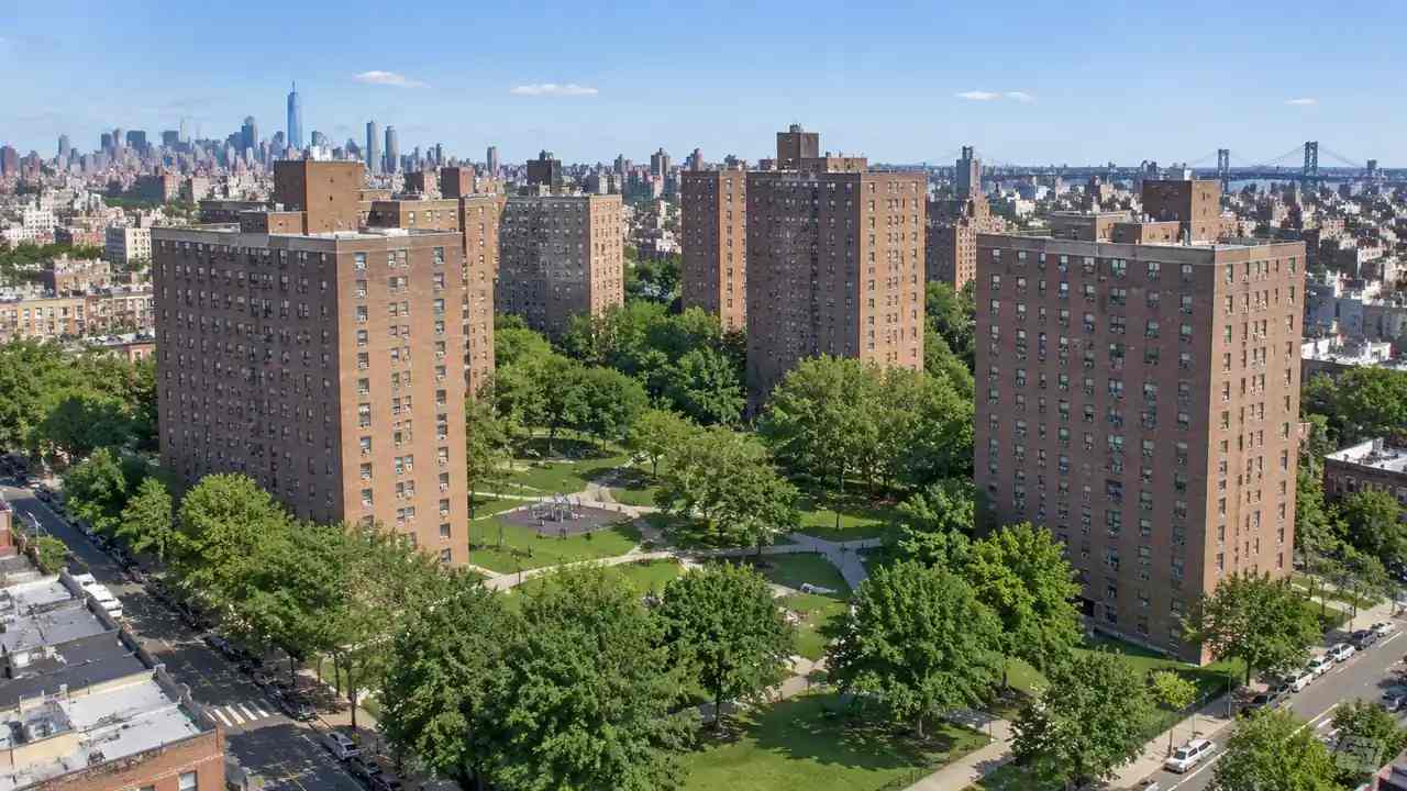
A public housing site the size of several city blocks is hard to hold in one view. Teams working on a redevelopment have to balance new buildings, open space, parking, and resident access at the same time. A 3D site model gives those conversations a common base, which is useful long before any design is fixed.
1 What a large housing site asks of a team
A redevelopment at this scale is not a single building project. It is a sequence of moves across a site that already has residents, mature trees, and infrastructure in place. The planning question is often about order as much as form.
1.1 The scale problem
A plan sheet that covers the whole site makes buildings look small and open space look generous. A street-level view tells a different story. Teams need to move between the two scales, and a model makes that movement easier than a stack of drawings.
1.2 Why existing conditions matter
Residents know which path floods, which courtyard is used for gatherings, and which entrance feels unsafe at night. Those facts rarely appear in a site survey. A model gives the team a place to record them, even if the initial version is built from map data.
That record changes the quality of the options. A team that has mapped the flooded path and the popular courtyard will not propose a layout that ignores them. The model becomes a container for local knowledge, not just a picture of roofs.
2 Reading the Nostrand Houses site
The site sits in a dense part of Brooklyn, with towers, low-rise streets, and a network of public and private open space. Understanding that setting is the starting point for any option.
2.1 Towers, open space, and circulation
Tall buildings cast long shadows and create wind at ground level. The arrangement of towers also decides how people walk from a building entrance to the street. A model can show both the shadow pattern and the walking routes at a glance.
Service routes deserve a look too. Trash trucks, deliveries, and emergency access all need a path that does not conflict with a play area or a building entrance. Those routes are easy to overlook when the discussion focuses on building form.
2.2 Streets, transit, and neighborhood edges
A redevelopment changes how the site meets the surrounding blocks. New buildings can open a view, close a path, or shift a bus stop's catchment. A model that includes the neighboring streets helps the team see those effects before a design is drawn.
3 Building a base model for options
An options process needs a base that everyone trusts. That base does not have to be detailed, but it has to be consistent.
3.1 What the model shows
GenAnywhere builds an editable 3D site model from an area selected on a map, using satellite and map data. It identifies building footprints, estimates heights, infers building types, and reads surrounding vegetation. Terrain, water, buildings, and vegetation sit in separate layers, so a team can show the towers, the open ground, or the tree canopy on its own.
The model can be previewed in the browser and exported as GLB for 3D, BIM, GIS, or game engine workflows. A planning team can use it to prepare views for a resident meeting or a design workshop. The model is a planning aid, not a survey product, and it does not carry survey coordinates.
3.2 Testing massing and open space
Place simple masses where new buildings might go, then look at the site from the street and from above. The exercise can show whether a courtyard would stay open, whether a path would become a wind tunnel, or whether a new building would block a view that residents value.
Try two arrangements rather than ten. A small set of clearly different options produces a better conversation than a long list of variations. The team can refine the chosen direction after the residents have weighed in.

4 Working with residents and agencies
4.1 Questions residents ask
Residents want to know where they would live during construction, whether their building would be demolished, and how the site would feel afterward. A model cannot answer those two questions, but it can show the physical result of a proposed layout. That helps separate a planning question from a relocation question.
Show the site at different times of day as well. A courtyard that looks sunny at noon may be shaded in the afternoon, and a path that feels open in summer may be windy in winter. Simple shadow views make those differences visible.
Keep the language plain. Terms like massing, setback, and floor area ratio are useful to the design team but alienating in a resident meeting. A model lets the presenter point at a shape and describe it in everyday words.
4.2 What to bring to an agency review
Agency reviewers need a clear site plan, a description of the existing conditions, and a set of views that show the proposed change. A model can supply those views and a file that staff can explore. HUD publishes guidance on public housing programs that helps a team understand the review context.
Bring a short list of assumptions with the file. Reviewers will ask which buildings are existing, which are proposed, and which heights are estimated. A clear legend prevents a long round of clarification.
5 Phasing and documentation
5.1 A phase-by-phase view
A redevelopment may take years and move across the site in stages. A model can show each phase as a separate layer, so the team can compare the site before, during, and after construction. That view is useful for planning temporary access and staging areas.
A phased view also shows residents that the whole site will not be under construction at once. A phased view can reduce anxiety, provided the team is honest about the uncertainty in the schedule.
5.2 Keeping a record
Save the model at each major decision point, with a date and a short note. The archive becomes a record of what was considered and why a direction changed. That record is valuable when staff move on or when a new agency reviewer joins the project.
Keep the files in a shared location with a clear naming rule. A folder of versions named final and final2 is a warning sign. Dates and short descriptions are easier to manage.
A short memo that explains why a version changed is worth more than a perfect file name. New team members can read the memo and understand the reasoning, which reduces the chance of reopening a settled question. The archive becomes a form of institutional memory.
6 Planning with fewer blind spots
6.1 When the model helps
The model helps when the team needs to compare layout options, explain a change to residents, or brief an agency without a site visit. It is also useful for showing the relationship between new buildings and the surrounding streets.
GenAnywhere fits the early part of that work because the scene comes from a map selection and opens in a browser. A team can review the layers with residents and export a file for the design consultants in the same session. It is not a replacement for architectural design or engineering.
The model is also useful for onboarding. A new staff member can explore the site in a browser and understand the layout before a walking tour. That shortens the time between arriving on the project and contributing to it.
6.2 When to bring in specialists
Bring in architects for building design, engineers for structure and utilities, and a landscape team for open space. Bring in a relocation specialist for the resident transition, which is a separate discipline with its own rules. The model can frame their work but cannot do it, and it should not be used to shortcut any of those reviews.
6.3 A next step
Pick one phase of the site and build a model of the surrounding blocks. Open GenAnywhere, select the area, and review the workflow before the next design workshop.
7 FAQ
FAQ-1 Can GenAnywhere show apartment interiors?
No. The model represents the exterior scene, including building footprints and estimated heights. Interior layouts, unit counts, accessibility features, and the number of bedrooms come from the current architectural drawings. A team can use the model to discuss the site, then rely on the design documents for everything inside the walls.
FAQ-2 Does the model include ownership or tenant data?
No. It is built from map and satellite data and does not contain ownership records, leases, or tenant information. Those records come from the housing authority and other official sources, and should never be inferred from the scene. Teams should keep personal data out of any model shared for a public meeting.
FAQ-3 Can it model a phased rebuild?
Yes, as a planning exercise. A team can save separate versions that represent each phase and compare them side by side. The model does not schedule construction or resolve relocation questions, but it can show the physical sequence and help residents understand what changes when, and it does not replace a relocation plan.
FAQ-4 Is the model useful for resident meetings?
Yes, if it is presented honestly. It gives residents a shared picture of the site and a way to point at specific corners. Label estimated heights, explain what the model leaves out, and leave time for corrections. The model supports the conversation; it does not replace it or serve as a legal record.
Content and technical notes
This article was prepared by the GenAnywhere team with AI-assisted drafting and human review.
Product features, formats, and availability change as the platform evolves; refer to the official GenAnywhere website for current details.
For technical questions or corrections, contact support@genanywhere.com.
Last reviewed: 2026-11-07.